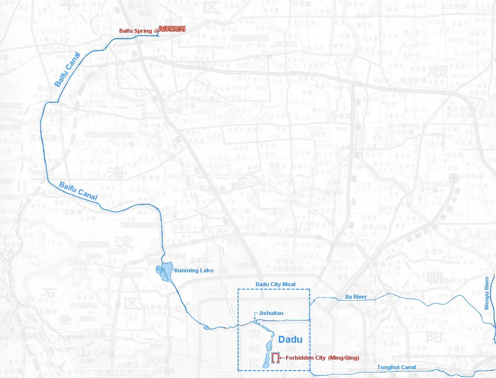
Baifu Canal - Origin
Place your mouse on any photo to pause slide show


Tranquility (1/6)
Your eyes may feast on this tranquil lake on a gorgeous and sunny early fall afternoon in 2004. Baifu Spring itself is located inside the wall on the left.
The dirt road leads in a semi-circle around the dilapidated holiday camp on the left. In the far distance are the northern hills of Beijing.
The photo is somewhat deceptive, however. Part of the bank is used as a garbage disposal dump rendering a less pleasant odor. Squatters inhabit the small islands in the center right of the picture.
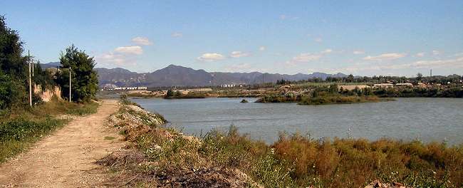
Baifu Spring (2/6)
This photo shows the spring that Guo Shou Jing found after extensive surveys of the topography of Beijing's surrounding area. The arrow points to the roof of the monument built over the actual spring inside the brightened circle.
The entire hill is cordoned off from the public and belongs to a private holiday park in a dilapidated state.
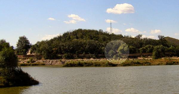
Another Forbidden City ? (3/6)
The monument is situated on the grounds of this private holiday village. The picture shows the main entrance gate, which is on the eastern side of the hill next to the lake.
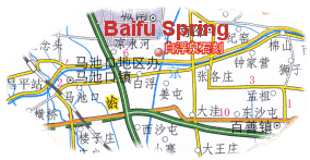
To get there exit the Badaling Expressway -green road on map above- direction Baifu. Go eastbound on the paved road (yellow road on map - see blue arrow) running alongside the northern bank of the Baifu Canal until you see the lake on your left.
Turn left right before the lake, go north some 20 meters and then take the narrow dirt road on the right; that's the one you see on this photo. You found it!
Unfortunately, the owner will only reluctantly allow access to this important monument of Beijing's history. And if you manage to talk him into letting you past the locked gate, then you must leave your camera behind.
But all is not lost …
The monument is situated on the grounds of this private holiday village. The picture shows the main entrance gate, which is on the eastern side of the hill next to the lake.
To get there exit the Badaling Expressway -green road on map above- direction Baifu. Go eastbound on the paved road (yellow road on map - see blue arrow) running alongside the northern bank of the Baifu Canal until you see the lake on your left.
Turn left right before the lake, go north some 20 meters and then take the narrow dirt road on the right; that's the one you see on this photo. You found it!
Unfortunately, the owner will only reluctantly allow access to this important monument of Beijing's history. And if you manage to talk him into letting you past the locked gate, then you must leave your camera behind.
But all is not lost …
The Monument (4/6)
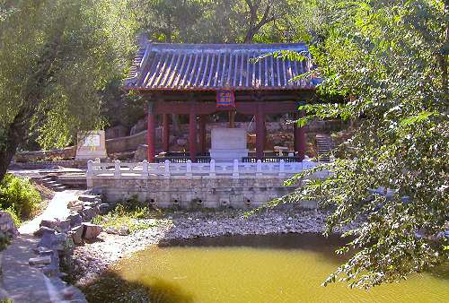
… because here is a picture of the monument itself. I'd rather not say how I got it, but it did not involve breaking any of their somewhat overdone rules!
The spring has dried up a long time ago. Only the small pond in front of the monument bears witness to the former function of this historic location.
The single eave building, erected on the spot where the spring used to flow, contains a stone tablet, which explains the role Baifu had in earlier times and heralds the achievements of Guo Shou Jing.
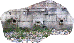
The front of the monument has nine fountain heads each decorated with a dragon head, the center one being a little different than the others (photo below). Water used to spirt from these, but also that has ceased.
… because here is a picture of the monument itself. I'd rather not say how I got it, but it did not involve breaking any of their somewhat overdone rules!
The spring has dried up a long time ago. Only the small pond in front of the monument bears witness to the former function of this historic location.
The single eave building, erected on the spot where the spring used to flow, contains a stone tablet, which explains the role Baifu had in earlier times and heralds the achievements of Guo Shou Jing.
The front of the monument has nine fountain heads each decorated with a dragon head, the center one being a little different than the others (photo below). Water used to spirt from these, but also that has ceased.
From the Spring into the Canal (5/6)
In the 1200's the water from the spring was collected in the lake, which again emptied south into the then newly excavated Baifu Canal.
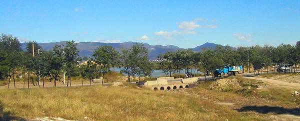
Nowadays the lake feeds a mostly dry river starting just south of the lake. The water flows under the road through the six circular openings in the center of the photo above. The arrow points to the north-south running river on the map at the top.
Unbelievably, the river bed traverses the modern successor to Beifu Canal -Miyun Irrigation Canal, which actually runs in huge pipes a few meters under the river bed on the photo -exactly beneath the dark shadow in the foreground (right) of the picture.
In the 1200's the water from the spring was collected in the lake, which again emptied south into the then newly excavated Baifu Canal.
Nowadays the lake feeds a mostly dry river starting just south of the lake. The water flows under the road through the six circular openings in the center of the photo above. The arrow points to the north-south running river on the map at the top.
Unbelievably, the river bed traverses the modern successor to Beifu Canal -Miyun Irrigation Canal, which actually runs in huge pipes a few meters under the river bed on the photo -exactly beneath the dark shadow in the foreground (right) of the picture.
The Start of Baifu Canal (6/6)
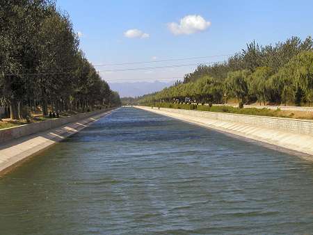
And so the journey down the 700+ years old Baifu Canal commences. Granted, today's water starts many more kilometers further north, but it still travels through Guo Shou Jing's original canal!
This photo taken on a warm September afternoon 2004 looks west and captures the very first section of the Baifu Canal. The Western Hills serve as an appropriate grand backdrop of this historic location.
The next pages show snapshots of the canal going downstream. Use the buttons top right to navigate.